Sites
Building Economic Opportunity - Together
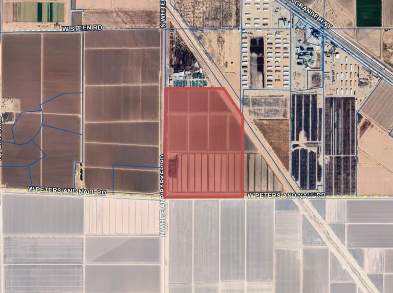
Nico Moric Industrial
West of N. White and Parker Road between W. Peters and Nall Road and W. Steen Road
- Total Acres: 194.00
- Total SF: 8,450,640
- Available SF: 8,450,640
Sorry, no records were found. Please adjust your search criteria and try again.
Sorry, unable to load the Maps API.
Core Property Information
Property Name: Nico Moric Industrial
Address: West of N. White and Parker Road between W. Peters and Nall Road and W. Steen Road.
Parcel Number: 50243002C
Total Acreage: 194
Zoning Designation: CI-2: Industrial Zone
Ownership: City of Maricopa
Site Characteristics
Aerial Map: Link to Map
ALTA Survey: Link to ALTA Survey
Floodplain Status: Not in the floodplain
Master Plan: Link to Master Plan
Utilities & Infrastructure
Electric Power Provider: Electric District 3 (ED3)
Water/Wastewater Provider: Global Water Resources (GWR)
Natural Gas Provider: Southwest Gas Corporation
Telecommunications Provider: Orbitel Communications
Transportation Access
Highway access: I-10: 15 miles, I-8: 18 miles
Proximity to Commercial Airport: Sky Harbor International Airport: 33.7 miles
Proximity to rail: Union Pacific Railroad: Less than 1 mile from the property.
Proximity to Port: 35.4 miles
Community Data
Population within drive times (3/5/10 miles): 5,701/ 55,069/ 84,978
Median household income (3/5/10 miles): $90,431/ $91,075/ $92,586
Median age (3/5/10 miles): 34 years/ 37 years/ 38 years
Educational institutions: K-12 Maricopa Unified School District (MUSD) which includes Maricopa High School & Desert Sunrise High School, also Heritage Academy Charter High School, A+ Charter High School, Student Choice High School, and Central Arizona College.